The yearning to reconnect with their traditional roots. You can read the article on the Daily Monitor website.
By Alfred Tumushabe
‘East or west home is best,’ is a popular saying which denotes the special value and affinity some people attach to their traditional homes and environments.
When people migrate to new areas to find jobs, pursue studies or are forced away by wars and catastrophes, they always yearn to reconnect with their traditional roots and when conditions allow they go back to re-establish themselves in their ancestral lands.
This very sentiment is reigning among the Batwa, the former forest people in south-western Uganda. The ethnic group had for centuries lived in the jungles of Bwindi and Mgahinga with wildlife as hunters and fruit gatherers until 1991 when the government evicted them from their ancestral dwelling to pave way for the wild life conservation.
The forests, located on the Uganda, Rwanda and DR Congo frontiers, are protected as Bwindi Impenetrable National and Mgahinga Gorilla National Parks. About 3,000 Batwa (about 96 per cent of Batwa in Uganda) people who were evicted are in Kigezi sub-region, according to the United Organisation for Batwa Development in Uganda (UOBDU).
About 1,598 live in Kisoro, 774 in Kabale and 665 in Kanungu districts, and a few others are in Bundibugyo and Kasese districts. Two decades outside the forest life, Batwa are still unable to compete on equal terms with other ethnic groups in Uganda and they remain marginalised and the poorest section of the society. They believe they were owners and custodians of the forests but the government never allocated them alternative land, which is a violation of their human rights.
They live destitute lives as squatters on other people’s land and their hopes for government help remain just a pipedream. “Government has never settled Batwa since we were chased from the forests. We are squatters on other people’s land,” says Mr Elias Habyarimana, the chairman of Batwa community in Uganda. He adds: “When the land owner is tired of you or you make a simple mistake you are immediately chased and you don’t have anywhere to run to. The government should give us land.”
Mr Habyarimana says that Batwa live on the streets of Kisoro Town as beggars and doing petty jobs. Some live on small portions of land given to them by non-governmental organisations like CARE and International and Adventist Relief Agency (ADRA) while others are squatting on the fringes of the forests.
Kisoro District Chairman Milton Mutabazi justifies their claim. “Most of them are squatters. I think their plight needs to be addressed,” he says.
Worse still, in the areas where they live, Batwa are excluded from community activities due to illiteracy and are victims of tribal prejudices. For instance, they cannot intermarry with other tribes. This segregation stops them from freely mixing with others in schools, hospitals and places of worship.
“The [Kabale] district has built health centres and schools near their camps but surprisingly women don’t come to deliver from there or seek other health services, they prefer to use herbs. And very few of their children go to schools,” says Kabale Chairman Patrick Kaihwa.
Despite being widely acknowledged as having the greatest knowledge of Bwindi and Mgahinga forests, Batwa have had no formal role in the conservation of the wildlife.
Only recently, UOBDU through Forest Peoples Programmes and Uganda Wildlife Authority (UWA) has come up with initiatives to exploit their knowledge of the forests so as to give better services to the tourists, render economic support and preserve Batwa traditional knowledge.
Assisted by UOBDU, 64 Batwa elders and clan heads that possess vast knowledge of the impenetrable forest have drawn a detailed map capturing all physical features and important spots in the jungle, some hitherto unknown to the wildlife conservation workers in the area. They presented the map on July 20 to UWA, government officials and UOBDU funders at Mubano Hotel in Kisoro Town.
Developed with technical assistance of experts, it details the territories inhabited by various clans, hills, rivers, homes for gorillas, hot springs, mineral-rich spots, worshiping places, caves and gorges.
The map is to be used by UWA in wildlife conservation initiatives and it will be a record of the traditional knowledge and life of Batwa which will serve as a reference for their children and future generation.
“Such knowledge would directly lead to a better understanding of Bwindi and its biodiversity and allow an opportunity for Batwa to directly engage in the conservation of Bwindi. It is a documentation of Batwa’s traditional life which will be important to their children,” says Ms Penninah Zanika, UOBDU Programme Coordinator.
UWA Conservation Area Manager Bwindi-Mgahinga National Parks Pontious Ezuma says he was overwhelmed by the knowledge of the Batwa about the area and would use it to make his patrols in the 331sq Km forest.
Mr David Kiiza, a member of the Batwa community, said he was happy for the opportunity given to them to reflect on the forest life and for knowledge preservation that will go a long way to benefit “our children after we are long gone”. But the presentation of the map of the wildlife times evoked nostalgic feelings among the Batwa audience; about the deprived life, majority saying they can go back to the forests given the opportunity.
Ms Joan Singakayanje, another community member who looks to be in her 50s, says she still sneaks into the forest to worship and carry out other rituals. “I still know and locate our place of worship. It is near a swamp and I still go there to pray,” she says. She adds: “I have never had an injection in my life. I use herbs. Some of us can go back after all we are not better of where we are.”
Mr Habyarimana says they were friendly to the fierce wild animals that today, on mere sight, send many people scampering for their lives. “We lived with all sorts of animals; snakes and gorillas harmoniously. Whenever you met a snake it would wait for you to cross. No animals ever harassed us,” he adds.
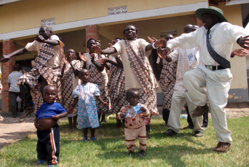
The presentation was climaxed with a Batwa cultural dance.Unfortunately, for Ms Singakayanje and others nostalgic about wildlife times, it will never be possible to return to their ancestral forest home.


